
South American river. The Essequibo River, whose ownership is not attributed to any particular country, has its source in the Acarai Mountains, near Brazil, on the border between Guyana Esequiba and Venezuela, an area that has been claimed for many years.

The Essequibo River and its source
The Essequibo River, with an important flow and length (1,000 km), originates in some mountains near Brazil, called Acarai Mountains, bordering with Guyana and Venezuela; it is disputed by these two countries, as there is a legal conflict for the ownership of this vast, valuable and rich area of South America, since 1814 (See: Iguazu River).
Map of the Essequibo
The Essequibo River winds its way through jungle, savannah and mountains for about 1,000 km before reaching the Atlantic Ocean, where it has many rapids and waterfalls that complement the irregular shape of the Guiana Massif. Many islands are formed in its estuary, including Hog, Leguan and Guaquenám (see: Seine River).

Claiming countries
Guyana Essequiba or Essequibo Territory, South American country; of its 214,970 sq km, 159,542 sq km have been claimed by Venezuela for more than a century under the Geneva Convention of February 1966, and Suriname claims 15,600 sq km in the south-east of the country.
Equatorial Guiana:
Located in the northwest of South America, it is bordered by the Atlantic Ocean to the north, Brazil to the south, Suriname to the east and Venezuela to the west. It has 430 km of Atlantic coastline. It sits on the Guiana Shield or Guiana Massif and its main river is the Essequibo.
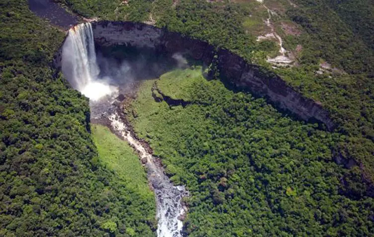
Among its most outstanding sites are the Kaieteur Falls, with a height of 226m, much higher than the Niagara Falls, 64m, in the United States (see: Río de La Plata).

Flora and Fauna
Being surrounded by jungle, the flora and fauna is very rich. Among them we can find trees of immense size, such as the water lily, which is very common in the area. The fauna includes a variety of colourful birds, monkeys, golden frogs, large lizards, snakes and wild tigers.
Venezuela:
A South American country of 916,445 square kilometres with a coastline of approximately 4,006 kilometres and small islands and islets in the Caribbean Sea. It is bordered by the Caribbean Sea and the Atlantic Ocean to the north, Brazil to the south, Guyana Esequiba to the east and Colombia to the west. Its tepuis in the state of Bolivar are a must-see among the country’s natural wonders.
The climate
Generally warm, it has three hydrographic basins: the Caribbean Sea, the Atlantic Ocean and Lake Valencia. On the Atlantic side, its largest basin is the Orinoco River, with almost one million square kilometres, equal to that of the Danube and the third largest in South America.

Historical background
Background to the Guyana-Venezuela conflict
Guyana was originally inhabited by the Arahuco and Carib Indians, who depended on hunting and shark fishing for their livelihood. This dates back to 1530-1531 when the territory was conquered by Diego Ordás. To define its boundaries, Spain built a fort on the banks of the Esequibo River between the Cuyuní and Mazaruni Rivers and took legal possession in 1594.
Dutch invasion
A Dutch invasion in 1615 mixed races and cultures and changed ownership. British Guiana was created in 1814 when the Dutch ceded the eastern part of the river to the British. This was the start of the border dispute between the two countries.

Venezuela, known since 1811 as the Captaincy General of Venezuela, claimed the disputed territories as its own and was recognised as such by Spain when Venezuela gained independence in 1845. The border areas were mapped and the Esequibo was recognised as the border.
Reasons for the dispute
The Essequibo is rich in gold, diamonds and large waterfalls with considerable hydroelectric potential. For this reason, the desire to take possession of these lands is a vital objective for both countries, and has led them to ignore the agreements of previous years which prohibit the use or exploitation of these lands.
The Dutch drew a new map in their favour, taking possession of 168,000 km east of the river, which passed to the British Crown, a fact confirmed by the Paris Arbitration Award in 1899, when it recognised more than 150,000 km that Venezuela had held since 1811. In 1948 it was considered a bad move to harm Venezuela and since then it has been considered a “zone in reclamation”.

Riches
These 159,000 square kilometres contain valuable mineral resources including bauxite, manganese, gold, diamonds, clay, silica, copper, uranium, iron, sand, hematite, oil and cocoa.
In 1966, the Geneva Agreement prohibited the granting of concessions to foreign companies while the legal dispute between the two nations was being resolved.
Exxon Mobile
Tensions flared again in 2016 when the US company Exxon Mobile, in violation of the Geneva Convention for the 15th time, carried out exploration work with Guyana’s permission and discovered large oil deposits. Exploration continues, despite several protests from Venezuela.
Hotels on the Essequibo
Guyana has some very interesting eco-tourism lodges on the banks of the Essequibo River. If you are looking for a holiday surrounded by nature, here are the most recommended options: Hurakabra River Resort, Aruwai White H20 Resort and Baganara Island Resort.
These lodges are ideal if you are looking for relaxation and adventure, you can walk through the jungle, visit waterfalls and see the local wildlife. The city of Georgetown is only an hour’s boat ride from the lodges, making it easy to travel and enjoy the adventure.