
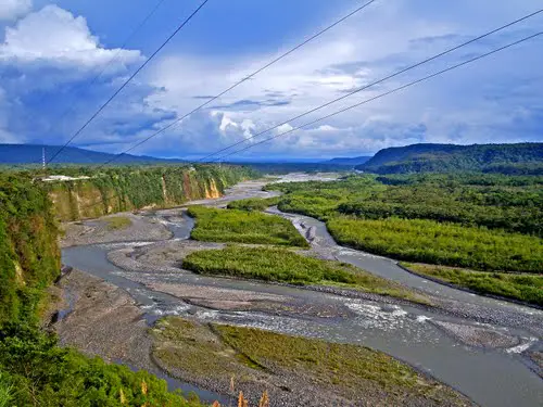
The Pastaza River is another of the beautiful rivers of the Amazon Basin that flows through the border regions between Peru and Ecuador.
Map of the Pastaza River
The Pastaza River, or former Sumatara River, flows from the area around the Tungurahua volcano towards the Peruvian mainland, crossing the Eastern Cordillera of the Andes.
Source of the Pastaza River
The white waters of the Pastaza River originate at the confluence of the El Altar and Chambo Rivers, on the slopes of the Tungurahua Volcano, in the province of the same name and near the town of Baños, Ecuador.
It is concentrated between the Sangay and Los Llanganates National Parks, between the Río Verde and Shell Rivers.
It flows into the Eastern Cordillera of the Andes and forms the Agoyán waterfall, which reaches a height of about 60 metres and where the hydroelectric plant of the same name is located (see also Caroní River). It then flows south-east into the Amazon, through a long stretch that runs along the border between the towns of Pastraza and Morona Santiago.
There it is fed by the waters of the Palora River on the right and the Capahuari and Bobonaza Rivers on the left, and soon approaches the natural border between Ecuador and Peru.
The course of the Pastraza River in Peru
Once in Peruvian territory, the Pastaza River flows south from Puerto Bobonaza through the Amazonian plains. It passes through Nuevo Andoas, Andoas and Puerto Pardo before joining the Huasaga River and then the Huitoyacu and Rimachi Rivers.
It crosses the sector of San Ramón and finally flows into the Marañón River, near the mouth of the Huallaga River.
Of its total length of 643 kilometres, the Pastaza River flows for about 370 kilometres through the Peruvian department of Loreto.
It is a fast-flowing, canoeable river with frequent waterfalls and sandbars. It rains heavily throughout its basin, causing flooding along its banks.
It does not have many communities around it, as it flows through virgin areas of the Amazon basin (see also Amazon River), inhabited only by the Zápara Indians.
Pastaza River: Ramsar site
This beautiful river forms the Pastaza River Fan Wetland Complex, which was declared a Ramsar site on 5 June 2002. It is located in the Achuar territory, in Loreto, and has several rivers, lakes, swamps and forests in an area of 3,827,329 hectares.
This region consists of a configuration of volcanic sediments that have been displaced from the Ecuadorian Andes to lie along the Pastaza River, its surrounding waters and the slopes of the Marañón.
Roads on the Pastaza River
The Pastaza River has few bridges, most of which are located in Tungurahua, north of the town of Baños, and at the level of the Agoyán Dam, where the Agoyán Hydroelectric Plant operates, at the level of the waterfall of the same name.
Other passes are suspension, pedestrian or with access to small vehicles, but in the dry season you can travel across the plains below the town of Mera in 4×4 vehicles. Also in Ecuador, there is a road between Ambato and El Puyo.
In Peru, between the Pastaza River and the Marañon River, there is a thriving economy development due to the presence of oil deposits, gold mining and timber exploitation.
Attractions of the Pastaza
The Pastaza River basin is home to a wide variety of orchids with beautiful shapes and colours, as well as the Carolina bat and 42 different species of birds.
Illuchi-Sauces Trail: This is an area much sought after by sportsmen and adventure lovers, considered the balcony of the Pastaza River. It starts in San Vicente, crosses the hanging bridge of the willows and ends at the bridge of San Francisco.
Ecological Corridor Llanganates – Sangay: It is located in an extension of 47 km, with an extensive endemic flora and fauna, which has received several scientific studies by the WWF, which awarded it the prize A GIFT FOR THE EARTH, in the year 2000. It includes beautiful and world-famous tarabitas and ecological trails that are attractive to tourists.
Kayaking and rafting: In the Pastaza River, along with other whitewater rivers such as the Patate, Topo and Verde, kayaking and rafting can be done on levels 3, 4, 5 and 6 (see also Pacuare River).
Cañón de San Martín Río Pastaza: The Pastaza gorge is 45 metres high, has a slope of about 90 degrees and is 5 metres wide.