
The Lempa River is the second longest river (not that it is very long) in Central America. It belongs to three countries because it flows through all of them: Guatemala, Honduras and El Salvador. It is a great curiosity to get to know its wide basin with its diverse environments.

Lempa River
The Lempa River is one of the longest rivers in Central America, flowing for more than 400 km through three important neighbouring countries: Guatemala, Honduras and El Salvador. It is also known as the longest river in El Salvador.
Origin of the word
Its name is etymologically ambiguous. Its translation from Lithuanian into Spanish results in the word “lámpara” (lamp) and is the only explanation of its source or origin. It is of great importance to the people living in its basin, since its waters are used for human consumption, agriculture and the generation of electricity for almost the entire population.
Its 422 km length does not exempt it from being of great importance and beauty within its geographical region, well because, as everyone knows, America itself has a vast flora, fauna, resources and natural monuments, and the fact of belonging to it makes it rich and valuable for its basin and for other countries around it, up to its mouth in the Pacific Ocean.
Lempa River: map
This map of the Lempa River clearly shows the route and location of the river between the three countries.
Location
The Lempa River is located in Central America and flows through three countries that make up its 17,790 square kilometre basin. Central America is part of the American continent and, as the name suggests, lies in the middle between North and South America.
Central America is made up of Guatemala, Belize, Honduras, El Salvador, Nicaragua, Costa Rica and Mexico (only the state of Chiapas) and its 522,760 square kilometres include the Isthmus of Panama and the Isthmus of Tehuantepec.

Source
Where does the Lempa River originate? We start in Guatemala, in Chiquimula, in the east of the country, also known as La Perla del Oriente (The Pearl of the East). It is in the middle of a volcanic and mountainous area where the rivers Chacalapa, Tepoctún, La Planta and Olopita converge. It is here that the Lempa River has its source and begins its pilgrimage towards Honduras, crossing the border with El Salvador after travelling 30 km in its region of origin.
It continues its journey for another 360 km until it reaches its mouth in the largest ocean in the world, the Pacific Ocean, in Tecoluca, between San Vicente (capital of the country between 1834 and 1840) and Usulután, departments of the Republic of El Salvador. Some call the Lempa River the Amazon River of Central America.
Lempa River Basin
The basic concept of a “basin” indicates that it is “a geographical and hydrological unit made up of a main river and all the territories included between the headwaters and the mouth of that river”. This concept is very aptly applied here, since any issue affecting the Lempa River Basin affects its three member countries:
- El Salvador.
- Guatemala.
- Honduras.
Let’s take a look at the diversity of ecosystems, fauna, flora and landscapes that the Lempa River traverses. It covers 17,790 square kilometres in three countries, Honduras, El Salvador and Guatemala, at an altitude of 1,500 metres above sea level. Of the three countries, El Salvador has the largest area covered by the river, with 10,215 square kilometres, or 56%, followed by Honduras with 5,472 square kilometres and Guatemala with 2,553 square kilometres.
Fauna and Flora
Amidst the grandeur of the Americas and its impressive vegetation, it is a luxury to travel through this basin, which undoubtedly has natural and man-made jewels that embellish everything in its path. Its waters provide crops and freshwater fauna with a life-sustaining, natural and ecological balance.
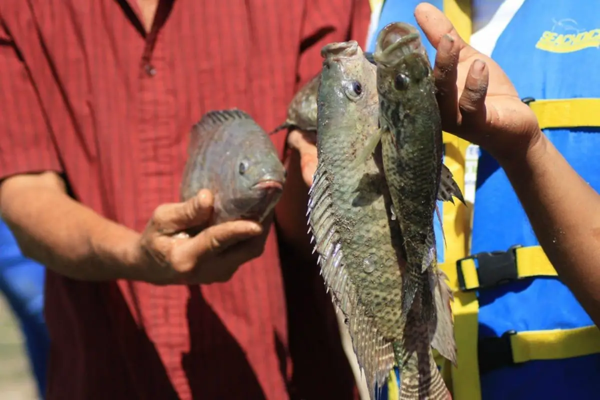
These rivers are rich in freshwater fish, so it is not uncommon to find mojarras, shrimps, molluscs, tilines, pupos and other species characteristic of their habitat. These species generate a considerable amount of money for the coffers of these governments thanks to the quality and good taste of their flesh, which is recognised in other countries and makes their marketing attractive.
Nancuchiname Forest
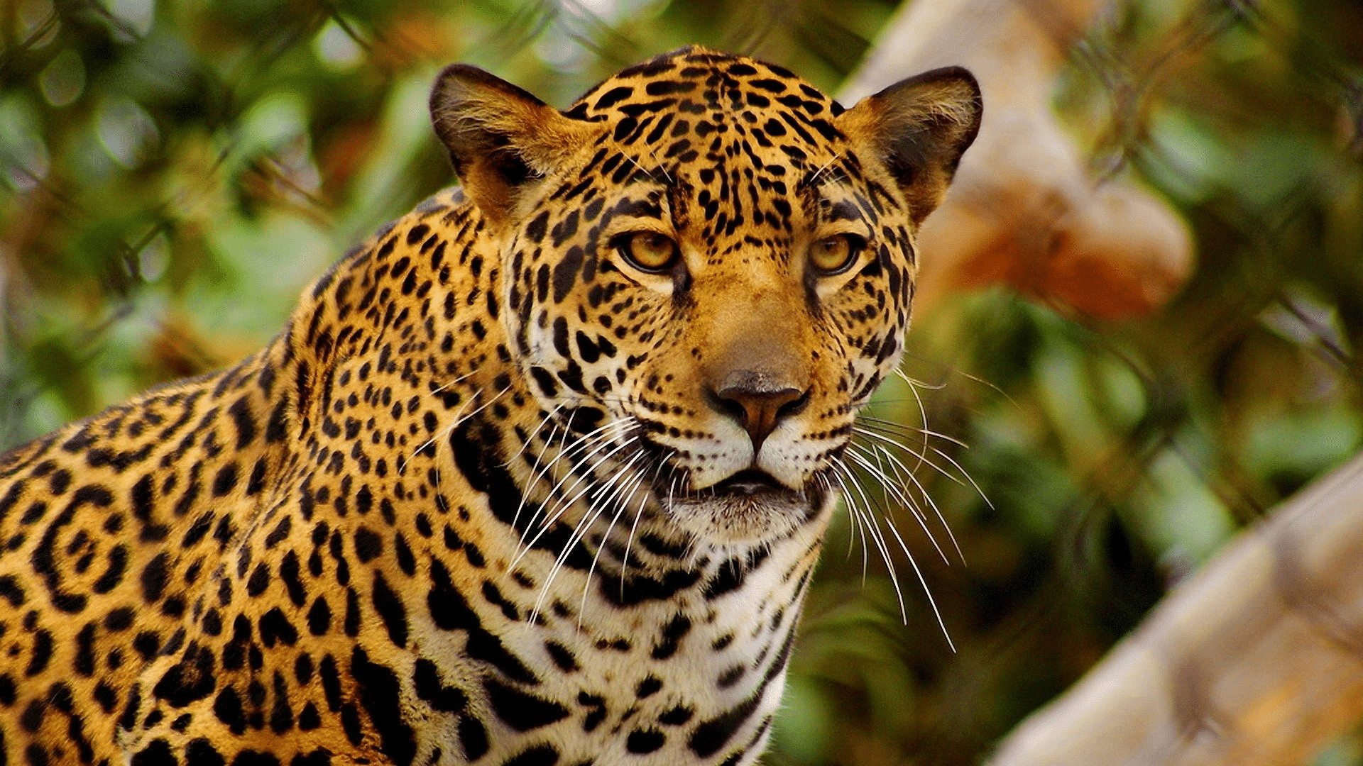
The Nancuchiname forest, a natural refuge before reaching the San Juan del Gozo peninsula in San Salvador, is home to spider monkeys and crocodiles along the river banks. The critically endangered jaguar, which is on the verge of extinction, is also a resident of the forest and measures are being taken to protect and conserve it.
Middle and Lower Basin
Entering through Guatemala, you can observe crystal clear pools, dense vegetation and many local and migratory birds: white herons, magpies, egrets, herons, ducks, among others of equal or greater colour and beauty. In the middle and lower basins, there are dry forests that become humid depending on the season, and it is a sector that has several tributaries and others that appear only with the rains.
There are fruit and timber trees, flowers such as orchids, native and others brought from other latitudes, which make up a striking and important variety for the country’s economy. In addition to orchids, exotic flowers of great beauty and value, there are avocado trees, a fruit highly valued in Guatemalan cuisine, and near the coast there are Caribbean pines, characteristic of the area. There is a large fauna in the area, raccoons, deer and several species of migratory birds.

Contamination
For several decades, the governments of San Salvador, Honduras and Guatemala have been addressing the problem of river pollution, concerned about the degradation and death of valuable species and the ecological damage to the river basins. Deforestation, illegal and indiscriminate logging, uncontrolled fishing and mining are also part of the problem.
In February 2007, the local people protested against the pollution of the Lempa del Salvador river and organised themselves to clean up the polluted waters and reverse the damage to their flora and fauna. The river is currently contaminated with arsenic (see: Río Pánuco).
It is extremely dangerous the level of contamination that many rivers and seas show, either by domestic and industrial waste, pesticides, herbicides, etc. (See: Tigre River).
Arsenic is one of the most toxic elements in river water. Its consumption gradually causes irreversible damage to the body. The consequences are usually seen within 5 to 20 years: cancer of the skin, kidneys and bladder.
Industry has increased the use of this chemical, which is so dangerous to the health of humans and animals who consume it by drinking or using the water from the affected rivers.
Video showing the terrible conditions in which the Lempa River finds itself as a result of the actions of man and the industries that cause so much ecological imbalance to the species.
Mining operations
Another environmental threat to the normal and healthy development of the Lempa River is mining. In Guatemala, the Marlin and Cerro Blanco mines are potential “killers” of the river, causing severe soil erosion, degradation and high sedimentation, which will endanger the life of the river.
The area occupied by Honduras, Guatemala and El Salvador covers 242,000 square kilometres, of which almost 72,000 square kilometres have been allocated to large mining companies, mainly in Honduras and Guatemala. In Honduras alone, 35,000 square kilometres have been concessioned, and in Guatemala there are 120 concessions.
The issue of intensive mining is being raised because of the environmental damage it would cause, both in the short and long term.
Hydroelectric Plants or Dams
These plants or dams, which are of great use and benefit to the inhabitants, the communities, the country and all that they can encompass, are also the great culprits of the degradation and death of the rivers, including their animal species, their trees, all living species.
Dams in El Salvador
In El Salvador alone, there are four dams that generate electricity, the most famous being the Cerrón Grande dam, which produces 170 MW, small compared to the 525,000 MW of the Saucelle dam on the Duero river, and has a capacity of 2,180 million cubic metres; the Guajoyo dam; the 5 de Noviembre dam; and the 15 de Septiembre dam.

Electricity generation is one of the most important facets of the Lempa River in El Salvador, along with fishing and the cultivation of cotton, rice, sugar cane, pasture and other no less important crops. In Guatemala, for example, they are taking seriously the idea of becoming independent of oil and generating energy that can supply the country, and proof of this is that they already have nineteen (19) hydroelectric plants or dams.
Floods
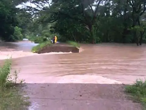
Threats to the Lempa River include the constant flooding and overflowing of its banks as a result of heavy rains and climate change, which has been affecting the river for the past decade. There have been floods so severe that they have inundated up to 60,000 square kilometres, as happened on the Mississippi River, where nearly 250 people lost their lives.
Flooding on the Mississippi is most common in winter, when the river floods more frequently. This is a problem for local people who have to deal with the rising water. Not only that, but it also leaves a potential reservoir for mosquito larvae that carry dengue fever.
Volcanoes in the Lempa River Basin
As the Lempa River flows through El Salvador and Guatemala, it encounters ancient and historic volcanic areas that are part of a larger number of volcanoes in Central America, considered a zone of high volcanic activity. Many are still active.
Guatemala
There is Acatenango, 3,976 metres high, also known as Tres Hermanas; Alzatate, 2,045 metres high; and Amayo or Cerro Las Flores, 1,544 metres high.

El Salvador
It is the cradle of the Santa Ana volcanoes, 2,382 m high, located in one of the highest places in El Salvador. Llamatepec, 2,382 m high, erupted in 2005, as did Santa Ana. The San Vicente volcano is 2,173 m high and around it there are springs of thermal water, also called “infiernillos”, with strong vapours and fumes.
The Conchagua volcano is 1,243 m high, it has an ecological park and two hills known as Cerro Ocotal and Cerro Banderas, both without volcanic activity. The Izalco Volcano is considered to be one of the youngest volcanoes in the Americas. It is 1,965 metres above sea level and its eruptions could be seen from the sea, which is why it is also known as the Lighthouse of the Pacific.
Visitors
It has areas designated for the passage of tourists, such as Cerro Verde, San Blas and Los Andes. They have the appropriate services for the enjoyment and safety of visitors, such as ranger stations, car parks, toilets, campsites, catering facilities and much more.

San Salvador Volcano
The San Salvador volcano is 1,867 m high and has not been active since 1,917. At 2,130 m is the San Miguel volcano, which last erupted in 2013, forcing the evacuation of the nearest inhabitants.
Tajumulco Volcano
The highest peak in Guatemala is the Tajumulco volcano at 4,222m, which is now inactive and shows no volcanic activity. It is ideal for camping and climbing due to its cold and pleasant climate. It is a seismic zone, with more than 100 earthquakes recorded in one week in Conchagua and the Gulf of Fonseca.
Vegetation and crops
Potatoes, vegetables and sheep are grown on the slopes. The vegetation consists of pine, conifer and oyamel trees in the central part of the mountain; higher up, at an altitude of around 4,000 metres, the most common plants are mosses and zacatonales. The alpine tundra is replacing the pine and oyamel.
Honduras
Honduras has four (4) active volcanoes. The stratovolcano of El Tigre Island, which forms the five (5) km wide island; that of Zacate Island; Utila, a volcanic vent located in the Caribbean Sea, towards the north coast of Honduras; and Yojoa, a volcanic field located north of the lake of the same name. A stratovolcano is a type of conical volcano characterised by the number of layers formed by erupted and solidified lava.
Honduras is the country with 82% of its territory made up of mountains, but it does not have the highest mountains in Central America. The highest peaks or elevations in the Central Andes are over 5,000m above sea level. Among the most famous for their height are
- The Celaque Mountain, 2,870 metres above sea level.
- La Montaña de Santa Bárbara, 2,754 m above sea level.
- Cerro El Pital, 2.730 masl.
Countries through which the Lempa River flows
El Salvador is a Central American country whose capital is San Salvador. It is divided into 14 departments with economic, technical and administrative autonomy. Its territory covers 21,041 square kilometres, including 307 metres of coastline. It borders Guatemala to the west, Honduras to the north and east, the Gulf of Fonseca to the southeast and the Pacific Ocean to the south, 307 kilometres from the River Paz to the Gulf of Fonseca.
Tributaries
Its most famous tributaries are the Sucio, Suquiapa, Acelhuate, El Grande, Metayate, Quezalapa, Titihuapa, Mocal, Sumpul, Torola and Guarajambala. Along the first three, 35% of El Salvador’s population is concentrated.
Economic activity
El Salvador’s economy is based on manufacturing and services: products such as tobacco, furniture, chemicals and textiles are more important than coffee production. There are about fifteen free trade zones, with the textile industry dominating, with a significant flow of its parts to the United States. To facilitate trade, the dollar is accepted in the country’s economy, along with the local currency, the Salvadoran colón.

Among the most relevant data directly related to the Lempa River is this:
- The Lempa River is the longest river in El Salvador at 422 km. El Salvador occupies 56% of its basin, the rest being shared by Honduras and Guatemala.
- It is very important because it provides energy for a large part of the population.
- Its main tributaries, on the upper reaches of the Lempa, are the Sucio, Suquiapa and Acelhuate rivers to the south, and the Metayate river to the north.
- The commercial and traditional activities include fishing in its waters with quality species.
- Its great beauty attracts a large number of tourists throughout the year.
- Its waters are used for crops and livestock.
- Its soil is mostly volcanic. It has 23 volcanoes.
- Kayak enthusiasts often visit to enjoy its waters, as well as rafting and canoeing.
- Cerro El Pital has recorded a temperature of -2°C.

About Honduras
The capital of Honduras is Tegucigalpa, and the country is made up of extensive mountain ranges that cover about 65% of the country’s territory. Its surface area is 112,492 square kilometres. It is divided administratively into eighteen (18) departments and the predominant economic activity of its inhabitants is agriculture. The other main economic activities are commerce, finance and public services.
Relevant data
Among the information about Lempa River of El Salvador we can mention very relevant data such as
Its climate is determined by the two seasons of the year, a dry season and a rainy season. The average temperature throughout the year is 21° Celsius (70° Fahrenheit). It can reach 27°C in the lower altitudes.
There are about 744 species of birds, 231 mammals, 116 amphibians and 200 reptiles, 197 species of fish in the Atlantic and 387 in the Pacific.
Its longest river is the Coco or Segovia, 550 km long.
Its economy is based on agriculture. They are exporters of bananas and coffee. But the main use of the river is the generation of electricity through its large hydroelectric dams.

- Its coastline is 823 km long, distributed along the Caribbean Sea and the Gulf of Fonseca.
- The basin covers 5,251 square kilometres in Honduras and reaches its highest point at 2,805 metres above sea level (masl).
- Tourist attractions include diving, jungle visits, Mayan sites and indigenous villages.
- It has six (6) seaports and four (4) international airports.
- The Bay Island is the most visited place by foreign tourists, mainly from Central America.
- Located between two oceans, it has diverse habitats on its land.
- The first wind farm in Honduras is located in Cerro de Hula, and in the village of La Llave there is a photovoltaic solar power plant, the largest in Latin America.

About Guatemala
Central American country whose capital is Guatemala City, officially known as Nueva Guatemala de la Asunción. It is also home to the Lempa River, which crosses its territory. Its diversity in general also includes cultural diversity, there are several languages, religions, methods of land use, artistic manifestations, crops, diets…
Basins
There are three (3) hydrographic basins: The Pacific basin, where the rivers are small, not more than 110 km long. The Caribbean slope, where the rivers are longer, including the Motagua, the country’s main river, with 486.5 km, and the Gulf of Mexico slope, which also has longer rivers, such as the Usumacinta, the Chixoy and the La Pasión.
Relevant data
Here are some interesting facts about the Lempa River:
- It has 108,889 square kilometres; eight (8) regions and 22 departments.
- They are heirs of the Mayan civilisations and the Spanish colonisers.
- Its territory is mainly mountainous.
- The Tajumulco volcano is its highest peak at 4,220 metres above sea level; earthquakes are frequent as it is a highly seismic zone.
- Its longest river is the Motagua, 486 metres long.
- Its soil is the country’s greatest resource, as are its minerals: petroleum, iron, zinc, lead, nickel and chromite.
- Since 2006, uranium, mercury and gold have also been mined.
- Its fauna includes 192 species of mammals and 486 species of birds; Guatemala is the world leader in the diversity of apulmonid salamanders, with 41 species, and a smaller number of toads and frogs.

- Its tree species include rubber, mahogany and ebony; timber is exported, as is small quantities of oil.
- Guatemala is a volcanic country, the best known and most important being the Tajumulco, Tacaná, Agua, Fuego and Pacaya volcanoes, the latter of which is very active.
- The lakes of Atitlán and Amatitlán are volcanic and their waters are extremely hot and sulphurous.
- Its tributaries include the Suquiapa, Sucio and Acelhuate rivers in the south and the Metayate river in the north. They include the upper reaches of the Lempa River, where 35% of the population is concentrated.
- The country produces and exports sugar, coffee, bananas and plantains. It is the world’s largest exporter of cardamom (a highly prized spice).

- They live from agriculture and tourism. Industry also plays an important role.
- They also grow tobacco, fruit, vegetables and other non-traditional crops such as broccoli, sesame, Brussels sprouts, asparagus and chilli, to name a few.
- There are gold, silver, jade and copper mines. Nickel is also mined and exported with some importance.
- Millions of tourists visit the country every year, mainly on cruise ships, to enjoy the archaeological areas, beaches, lakes, colonial and natural sites.
Curiosities
There are many curiosities about the Lempa River and all the information about it, here are many of them.
In January of this year, traces of pre-Hispanic cultures were found north of Chalatenango and on the banks of the Lempa River. Petrographs and cave paintings with a predominance of red colour.
The Lempa River, after being a priceless treasure of El Salvador and the pride of its inhabitants, could become the most polluted with sewage and a torturous river.
The Mayan culture had a great influence in El Salvador, Honduras and Guatemala in the 2nd and 3rd centuries until the 16th century, which culminated in the Spanish conquest.
The video below gives a more detailed explanation of the important influence the Mayan civilisation had on the Lempa River basin.
Sonnet dedicated to the Lempa River
The Lempa River
(Sonnet)
Like a ribbon of honour descending
From side to side on the breast
So I see the Lempa River stretching out
Across the land on its bed.
With the breeze that comes from beyond
Swaying the nard trees and a fern
On the rippling water that spreads out
Under a sky of clouds for a roof.
From a hill I look down a long stretch
And a tular tree that swings before me
Seems like a heavenly reflection.
From above, my vision is restored
To see the river meander
Cadenced and with incomparable grace.
Perhaps because it is the most abundant, or perhaps because it divides my country in two.
Your memory of the Lempa River is as precious to me as the fields you nourish, green and blooming with corn leaves.
Olapa is what they call you when you are born in Chiquimula, Guatemala. In Ocotepeque, Honduras, Lempa means Lord in the Lenca language.
But even if these two nations are your antechamber, the 362 kilometres that you travel through my homeland, of your 422 kilometres that is your total length, make you more like ours, Rio Lempa of my love.
From the sky, you look like a silver thread that meanders serenely from El Salvador, through the fields, before flowing into the sea. Your three dams form a staircase that gives life to three beautiful lakes that look like lampos,
They become backwaters that sustain life and fill those who look at them with peace. Rio Lempa, you live in my memory, for in your basin I wrote more than one story that I can never forget.
Author: Sir Galahanth. Year 2.010.